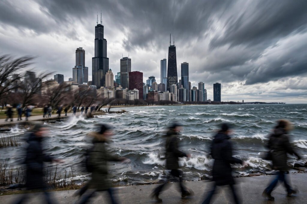
Why Is Chicago So Windy? The Scientific Explanation (2026)
Chicago’s nickname — the Windy City — is one of America’s great misnomers. It was popularized by a New York newspaper in the 1890s, and it wasn’t about weather at all: it referred to Chicago’s politicians being “full of hot air.” The irony is that the name stuck because it feels true. Stand on Michigan Avenue in February and the wind genuinely seems personal. So why is Chicago so windy? The scientific answer involves geography, pressure systems, and a lake that acts like a wind machine.
It’s Not Actually the Windiest City
First, the record needs correcting: Chicago is not among America’s windiest big cities by average wind speed. Boston, New York, and several Great Plains cities all record higher averages. Chicago’s average wind speed hovers around 10 mph — breezy, not extraordinary. What makes Chicago feel windy is the combination of wind with extreme cold (wind chill makes 10 mph feel brutal at 10°F), the urban canyon effect downtown, and genuinely gusty episodes that stick in memory more than averages do.
So the scientific question isn’t “why is Chicago the windiest” — it’s “why is Chicago windier than its latitude suggests, and why does it feel so extreme?” Those have real answers.
The Pressure Gradient: Caught Between Air Masses
Chicago sits in the crossfire of North America’s great atmospheric battle. To the north: cold, dense Arctic air masses. To the south: warm, moist Gulf air. Where they meet, pressure gradients form — and wind is simply air flowing from high to low pressure, faster when the gradient is steeper. Chicago’s location near the typical battleground means it experiences strong gradients frequently, especially in spring and fall when the contrast between air masses is sharpest.
The jet stream amplifies this. Chicago sits near the average position of the polar jet stream, the high-altitude river of air that steers storm systems. When the jet stream dips south in winter, it drags powerful low-pressure systems right over the Great Lakes — each one a wind event. The National Weather Service’s Chicago forecast office tracks these systems constantly; winter wind advisories are among their most-issued products.
Lake Michigan: The Wind Machine Next Door
The lake contributes in two ways. First, the flat, frictionless water surface lets wind blow unimpeded — air moving over Lake Michigan doesn’t lose energy to trees, hills, or buildings, so it arrives at Chicago’s shoreline at full strength. This “lake fetch” effect means shoreline winds routinely exceed inland winds by several mph.
Second, the lake creates its own local winds. In spring, when the lake is still cold from winter but the land warms quickly, the temperature contrast drives lake breezes — cool air flowing from water to land every sunny afternoon. In fall, the pattern reverses as the warm lake heats cold air masses from below, adding energy to passing storms. NOAA’s Great Lakes research documents how the lake modifies wind fields across the entire southern basin, with Chicago sitting squarely in the affected zone.
The Urban Canyon Effect: Why Downtown Feels Worse
Here’s why visitors remember Chicago as brutally windy even when the airport reports 12 mph: downtown’s skyscrapers create wind tunnels. When wind hits a tall building, it’s forced around and between structures, accelerating through the gaps — the same Venturi effect that makes wind whistle through a cracked window. Street-level gusts between Loop towers can easily double the official wind speed, and the effect is strongest exactly where pedestrians are: at sidewalk level, between buildings, on bridges.
This is an urban design phenomenon, not a meteorological one, but it’s the dominant wind experience for millions. The famous “windy corners” of downtown Chicago — intersections where the canyon geometry focuses gusts — are consistent enough that locals plan routes around them in winter.
Seasonal Patterns: When It’s Worst
Chicago’s wind has a calendar. Late fall through early spring brings the strongest sustained winds, driven by powerful low-pressure systems and the sharpest air-mass contrasts. March and April are typically the windiest months — spring’s clashing air masses produce frequent gusty days. Summer is calmest, though lake breezes provide daily afternoon relief. The extreme events — the 60+ mph gusts that make news — almost always come from deep low-pressure systems in the cold season, sometimes combined with the lake’s added energy.
Climate trends may be shifting this pattern subtly: a warming Arctic is changing jet stream behavior, with some research suggesting more persistent, wavier patterns that could alter Midwestern storm tracks. The science is still developing, but Chicago’s wind regime in 2050 may differ measurably from today’s.
Living with it is a practical skill. Layering for cold weather without looking bulky is essential Chicago knowledge — wind cuts through single heavy layers but not smart ones. And since the wind finds every crack in older buildings, stopping your house from feeling drafty in winter is the home-front version of the same battle.
The Famous Storms: When It Gets Extreme
Chicago’s wind legends come from specific events, not averages. The Armistice Day Blizzard of 1940 dropped temperatures 50 degrees in hours with 80 mph gusts. The 1967 blizzard buried the city under 23 inches with winds that created 15-foot drifts. The 2019 polar vortex brought -55°F wind chills that made national news. Each was a textbook pressure-gradient event: a deep low-pressure system tracking near the lakes, tightening the gradient over Chicago precisely. These episodes — rare, violent, memorable — are what the nickname really memorializes.
Conclusion
Chicago is windy for scientific reasons, not just reputational ones: its position between clashing air masses creates strong pressure gradients, the nearby jet stream steers powerful storms overhead, Lake Michigan delivers frictionless winds and lake-breeze cycles, and downtown’s skyscrapers amplify it all into the gusty canyons pedestrians know too well. The nickname may have started as political trash talk, but the physics backed it up. The Windy City earned its name the hard way — one February gust at a time.
Frequently Asked Questions
Is Chicago really the windiest city in America?
No — the nickname came from 1890s politics, not meteorology. Cities like Boston and Amarillo have higher average wind speeds. Chicago feels exceptionally windy due to wind chill, lake effects, and downtown wind tunnels.
Why does downtown Chicago feel windier than the suburbs?
The urban canyon effect: skyscrapers force wind through narrow gaps between buildings, accelerating it. Street-level gusts downtown can double the official airport wind speed.
Why is wind chill worse in Chicago than the temperature suggests?
Wind strips away the thin layer of warm air insulating your skin, accelerating heat loss. At 10°F with 20 mph winds, exposed skin loses heat as if it were -9°F — which is why Chicago’s moderate winds feel brutal in deep winter.
What are Chicago’s windiest months?
March and April typically, when clashing warm and cold air masses produce frequent strong pressure gradients. Late fall through winter brings the most extreme gust events.
What was Chicago’s windiest day on record?
Extreme gust records cluster around historic blizzards and deep low-pressure systems — the 1967 blizzard and the 1940 Armistice Day storm both produced gusts near hurricane force, with wind chills among the worst ever recorded in the city.
Does Lake Michigan make Chicago windier?
Yes. The lake’s smooth surface lets wind travel without friction loss, and temperature contrasts between lake and land generate local lake breezes and energize passing storms.